
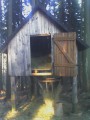
Seník pod Spělkovem
 Main info


2
/
4
GPS WGS84:
49° 40’ 44.16” N
16° 9’ 43.47” E
Added by: Kaja (18/04/2011 - 01:46:47)
Added by: Kaja (18/04/2011 - 01:46:47)
Map
Objects in the surroundings


There have been 13 other objects found in the area, if you know of any others, try adding them here...
Gallery
1951
1952
1953

There are 3 of pictures in the gallery, if you have some more, you can upload them here...
Description
Hospodářský seník ležící při žluté značce ze Spělkova do Telecího v romantickém údolí Svratky. toho času otevřený se senem.
Water source
...
Best time to visit
...
Access
Ze Spělkova žlutou dolů k řece (Svratce), seník je hned jakmile vstoupíte do lesa. Od silnice sotva 300 m.
Notes
04/07/2022 - 14:16:07
Seník tu stále je, i když už je to možná úplně jiný seník, je trochu blíž k vesnici, než je to na mapě. V červnu byl odemčený, ale bez žebříku a velmi plný sena. V noci tam létala sršeň, takže je možné, že teď už tam bude hnízdo. Buďte opatrní.
youradhere
There are 1 notes for this object...
© www.boudy.org | all informations without guarantee | PHP 8.3.30 | MySQL 11.4.10-MariaDB-ubu2204-log | last change: 06/01/2024 - 22:05:09 V.A.