
Drábské světničky
 Main info


6
/
8
GPS WGS84:
50° 31’ 52.69” N
15° 1’ 55.89” E
Link: http://wiki.mapy.cz/index.php/Drábské_Světničky_(zřícenina)
Added by: Myneur (27/07/2009 - 22:38:26)
Link: http://wiki.mapy.cz/index.php/Drábské_Světničky_(zřícenina)
Added by: Myneur (27/07/2009 - 22:38:26)
Map
Objects in the surroundings


There have been 6 other objects found in the area, if you know of any others, try adding them here...
Gallery
3326
There are 1 of pictures in the gallery, if you have some more, you can upload them here...
Description
- stone floor
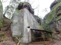
Zřícenina bývalého hradu, zbytky bývalého hradu, jeskyně vykutané do pískovcových skal. Několik přístřešků, v největším se pohodlně vejde 4-6 lidí, další je tak pro dva.
Water source
...
Best time to visit
...
Access
...
Notes
There is no comment on this object yet, so if you know something, try to add it here...
© www.boudy.org | all informations without guarantee | PHP 8.3.31 | MySQL 11.4.10-MariaDB-ubu2204-log | last change: 06/01/2024 - 22:05:09 V.A.