
Rauher Kamm
 Main info


2
/
4
GPS WGS84:
47° 51’ 52” N
15° 12’ 58” E
Added by: Kaja (19/05/2009 - 19:48:43)
Last edit: Lenka (19/05/2009 - 19:48:43)
Added by: Kaja (19/05/2009 - 19:48:43)
Last edit: Lenka (19/05/2009 - 19:48:43)
Map
Objects in the surroundings
No other object has been found in the area, if you know of one, please try to add it here...
Gallery
1665
There are 1 of pictures in the gallery, if you have some more, you can upload them here...
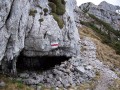
Description
- leeward
Nouzový úkryt přímo v rozeklaném hřebeni Rauher Kamm při výstupu na majestátný Ötscher(1893m). Místo pro 3 osoby, skvělý rozhled.
Water source
Vápencová oblast, vody obecně málo.
Best time to visit
Asi kdykoliv...
Access
Bivak je na značené cestě Trübenbach-Bärenlacken-vrchol Ötscheru. Cesta vychází prudce a dlouho serpentinami lesem až na hřeben, poté stoupá stále hřebenem až na vrchol Ötscheru. Bivak je v dolní části hřebene kousek za odbočkou cesty k jeskyni Geldloch (a dále do Ötschergraben).
Notes
There is no comment on this object yet, so if you know something, try to add it here...
© www.boudy.org | all informations without guarantee | PHP 8.3.30 | MySQL 11.4.10-MariaDB-ubu2204-log | last change: 06/01/2024 - 22:05:09 V.A.