
Bývalá salaš pod Čertoryjemi
 Main info


...")


40
/
40
GPS WGS84:
48° 51’ 46.69” N
17° 25’ 53.7” E
Added by: M. Brychta (03/05/2009 - 19:37:45)
Added by: M. Brychta (03/05/2009 - 19:37:45)
Map
Objects in the surroundings


There have been 4 other objects found in the area, if you know of any others, try adding them here...
Gallery
1653
1654
There are 2 of pictures in the gallery, if you have some more, you can upload them here...
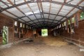
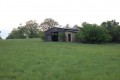
Description
Velká nepoužívaná salaš s plechovou střechou, místy děravou. Zbytky sláma, cihlová podlaha, otevřená vrata na obou stranách budovy.
Water source
- there is only utility water in the vicinity
Vodoteč asi 50 metrů pod salaší.
Best time to visit
Celoročně.
Access
700 mertů na jihozápad od rozcestí na hřebenu Výzkum - cesta od Malé Vrbky k nádrži Lučina nebo sejít se zelené tur. značky na vrcholu Čertoryjí dolů k potoku Radějovka - salaš je viditelná.
- 92 Slovácko - Bílé Karpaty - 1:50 000, čtverec 2 B
Notes
There is no comment on this object yet, so if you know something, try to add it here...
© www.boudy.org | all informations without guarantee | PHP 8.3.30 | MySQL 11.4.10-MariaDB-ubu2204-log | last change: 06/01/2024 - 22:05:09 V.A.