
Zřícenina hradu Stohánek
 Main info


...")


4
/
7
GPS WGS84:
50° 40’ 26.79” N
14° 50’ 33.18” E
Added by: PB (24/01/2009 - 18:05:18)
Last edit: Hynďa (14/10/2016 - 20:59:30)
Added by: PB (24/01/2009 - 18:05:18)
Last edit: Hynďa (14/10/2016 - 20:59:30)
Map
Objects in the surroundings


There have been 14 other objects found in the area, if you know of any others, try adding them here...
Gallery
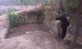
1627
04/02/2008 - 18:05:18
Vchod do jeskyně a prostor před ním.
PB
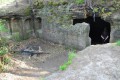
2820
08/05/2016 - 20:59:30
Terasa před "spací" místností
Hynďa
2821
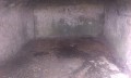
08/05/2016 - 20:59:30
Vnitřní prostor
Hynďa
2822
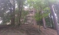
08/05/2016 - 20:59:30
Objekt se nachází na vrcholu této skály
Hynďa
2823
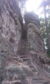
08/05/2016 - 20:59:30
Přístupová cesta
Hynďa
There are 5 of pictures in the gallery, if you have some more, you can upload them here...
Notes
There is no comment on this object yet, so if you know something, try to add it here...
© www.boudy.org | all informations without guarantee | PHP 8.3.30 | MySQL 11.4.10-MariaDB-ubu2204-log | last change: 06/01/2024 - 22:05:09 V.A.