
Seník Strážovský potok
 Main info


...")


5
/
10
GPS WGS84:
48° 58’ 17.46” N
18° 28’ 19.15” E
Added by: Kaja (27/05/2008 - 23:12:57)
Added by: Kaja (27/05/2008 - 23:12:57)
Map
Objects in the surroundings


There have been 14 other objects found in the area, if you know of any others, try adding them here...
Gallery
1506
03/02/2008 - 23:12:57
Kaja
1507

03/02/2008 - 23:12:57
Kaja
1508
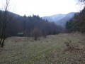
03/02/2008 - 23:12:57
Pohled od seníku k přístřešku.
Kaja
1509
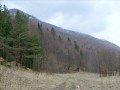
03/02/2008 - 23:12:57
Phled od přístřešku k seníku, vzadu skály vrcholu Sokolie.
Kaja
There are 4 of pictures in the gallery, if you have some more, you can upload them here...
Notes
There is no comment on this object yet, so if you know something, try to add it here...
© www.boudy.org | all informations without guarantee | PHP 8.3.30 | MySQL 11.4.10-MariaDB-ubu2204-log | last change: 06/01/2024 - 22:05:09 V.A.