
Seník nad Schladmingem
 Main info


...")


4
/
10
GPS WGS84:
47° 23’ 9.6” N
13° 42’ 55.8” E
Added by: Zdbartos (15/03/2008 - 22:51:27)
Added by: Zdbartos (15/03/2008 - 22:51:27)
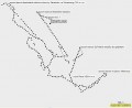
Map
Objects in the surroundings
No other object has been found in the area, if you know of one, please try to add it here...
Gallery
1454
03/02/2008 - 22:51:27
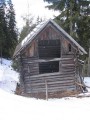
Pohled z jihu na vstupní otvor.
Zdbartos
1455

03/02/2008 - 22:51:27
Pohled ze západu na východ na seník a na značení sjezdovky (červený terč s číslem 1).
Zdbartos
1456
03/02/2008 - 22:51:27
GPS záznam mého pohybu v lyžařském areálu vč. polohy seníku, kabinky, dvou sedaček, jedné dvojkotvy a mnoha sjezdovek.
Zdbartos
There are 3 of pictures in the gallery, if you have some more, you can upload them here...
Notes
There is no comment on this object yet, so if you know something, try to add it here...
© www.boudy.org | all informations without guarantee | PHP 8.3.30 | MySQL 11.4.10-MariaDB-ubu2204-log | last change: 06/01/2024 - 22:05:09 V.A.