
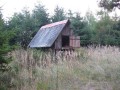
Seník u Kolaříku
 Main info


2
/
3
GPS WGS84:
49° 22’ 1.61” N
16° 6’ 5.1” E
Added by: Kaja (03/01/2008 - 20:21:01)
Added by: Kaja (03/01/2008 - 20:21:01)
Map
Objects in the surroundings


There have been 7 other objects found in the area, if you know of any others, try adding them here...
Notes
04/05/2014 - 00:54:44
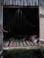
Seník již bohužel neexistuje. využijte boud v okolí.
Kaja
There are 1 notes for this object...
Gallery
1391
1392

1393
There are 3 of pictures in the gallery, if you have some more, you can upload them here...
© www.boudy.org | all informations without guarantee | PHP 8.3.30 | MySQL 11.4.10-MariaDB-ubu2204-log | last change: 06/01/2024 - 22:05:09 V.A.