
Ali-Lanti Biwak
 Main info


3
/
5
GPS WGS84:
47° 5’ 39.25” N
13° 16’ 19.35” E
Added by: Kája (04/05/2005 - 23:45:46)
Added by: Kája (04/05/2005 - 23:45:46)
Map
Objects in the surroundings

There have been 4 other objects found in the area, if you know of any others, try adding them here...
Gallery
171
172
173

There are 3 of pictures in the gallery, if you have some more, you can upload them here...
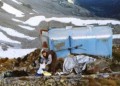
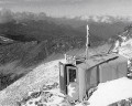
Description
- wooden bunk beds
- pillows
- table
Otevřená plechová bivakovací bouda, pro nouzové přespání cca 4 osob, ukotvený lany ve výšce 2663 metrů v sedle Kleidenerscharte mezi Jagerkogel a Keeskogel.
Water source
...
Best time to visit
Kdykoliv. Počítejte ale s opravdu minimálními rozměry bivaku.
Access
Přístup buď z Prossau (1270) značenou cestou Vinzenz-Havel-Weg nejprve ostře v serpentinách lesem k Kesselkarhütte (1760) a poté dlouze Kesselkarem přes dva často vysněžené prahy až do sedla nebo od přehrady Kölnbreinspeicher (1900) Kleinelendtalem přes stejnojmenou chatu až do sedla. Opět značeno
Notes
There is no comment on this object yet, so if you know something, try to add it here...
© www.boudy.org | all informations without guarantee | PHP 8.3.31 | MySQL 11.4.10-MariaDB-ubu2204-log | last change: 06/01/2024 - 22:05:09 V.A.