
Vyhlídka Semenec
 Main info


5
/
10
GPS WGS84:
49° 13’ 50.19” N
14° 24’ 36.22” E
Added by: Kája (02/05/2005 - 00:34:21)
Last edit: VA (10/06/2012 - 00:34:21)
Added by: Kája (02/05/2005 - 00:34:21)
Last edit: VA (10/06/2012 - 00:34:21)
Map
Objects in the surroundings

There have been 1 other objects found in the area, if you know of any others, try adding them here...
Gallery
974
02/02/2003 - 00:34:21
Lenka H
975

02/02/2012 - 00:34:21
Rozhledna od červené značky.
VA
976
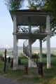
02/02/2012 - 00:34:21
Rozhledna Semenec.
VA
977
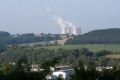
02/02/2012 - 00:34:21
Ranní Temelín. :-)
VA
978
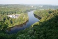
02/02/2012 - 00:34:22
Vltava.
VA
979
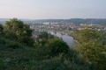
02/02/2012 - 00:34:22
Týn nad Vltavou.
VA
980
02/02/2012 - 00:34:22
"Interiér".
VA
981

02/02/2012 - 00:34:22
Schodiště. Procpat se tudy s naloženým kolem byl docela problém.
VA
There are 8 of pictures in the gallery, if you have some more, you can upload them here...
Notes
There is no comment on this object yet, so if you know something, try to add it here...
© www.boudy.org | all informations without guarantee | PHP 8.3.31 | MySQL 11.4.10-MariaDB-ubu2204-log | last change: 06/01/2024 - 22:05:09 V.A.