
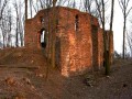
Hrad Fulštejn
Czech Republic, Zlatohorská vrchovina, Jindřichovská pahorkatina, Amalínská pahorkatina | 266 m a.s.l.
 Main info


5
/
10
GPS WGS84:
50° 14’ 14.38” N
17° 42’ 33.73” E
Added by: Dokup (20/04/2005 - 00:18:27)
Added by: Dokup (20/04/2005 - 00:18:27)
Map
Objects in the surroundings
No other object has been found in the area, if you know of one, please try to add it here...
Gallery
951
952
953

There are 3 of pictures in the gallery, if you have some more, you can upload them here...
Description
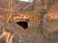
It is a stone bridge on the approach to Fulštejn Castle. It is almost covered from one side and thus forms a pleasant shelter where it does not blow much.
Please do not build a fire under the bridge, but on the designated fire pits.
Water source
...
Best time to visit
Anytime, unless there's an event going on. (see www.fulstejn.wz.cz).
Access
Route 1: From the parking lot of the campsite in Bohušov, take the wooden footbridge over the river and then follow the red marker.
Route 2: From the railway station in Bohušov follow the tracks towards Třemešná ve Slezsku to the signboard with information about the castle and then around it to the left along the path uphill to the castle.
- mapa hradních zřícenin
Notes
There is no comment on this object yet, so if you know something, try to add it here...
© www.boudy.org | all informations without guarantee | PHP 8.3.30 | MySQL 11.4.10-MariaDB-ubu2204-log | last change: 06/01/2024 - 22:05:09 V.A.