
Búda v Rybovskem sedle
 Main info


...")


4
/
8
GPS WGS84:
48° 52’ 39.46” N
19° 5’ 20.66” E
Added by: Kája (15/03/2004 - 22:51:56)
Last edit: Jarda Trnka (11/04/2014 - 22:51:56)
Added by: Kája (15/03/2004 - 22:51:56)
Last edit: Jarda Trnka (11/04/2014 - 22:51:56)
Map
Objects in the surroundings


There have been 44 other objects found in the area, if you know of any others, try adding them here...
Gallery
136
There are 1 of pictures in the gallery, if you have some more, you can upload them here...
Description
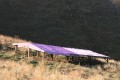
Shelter for sheep, about 100 m northwest of the signpost Rybovské sedlo, near the green sign. Height approx. 150 cm, clay on the ground, usable as an emergency shelter.
Water source
Water source 200 m southeast, on the opposite side of the saddle.
Best time to visit
Except for exposed holiday dates at any time.
Access
Access via the red sign Donovaly-Krížna is not to be missed.
- Mapa 121, Veľká Fatra, VKÚ Harmanec
Notes
20/04/2015 - 21:32:12
V létě 2014 u přístřešku pro ovce... bača s V3Skou... nechal nás přespat uvnitř auta, prostě super.
PoBo
12/10/2010 - 22:18:07
Salaš již nestojí (viz foto).
RoKi
09/09/2010 - 12:21:37
http://hiking.sk/hk/fo/1328/koliba_pod_repistom.html
mikeson
There are 4 notes for this object...
© www.boudy.org | all informations without guarantee | PHP 8.3.30 | MySQL 11.4.10-MariaDB-ubu2204-log | last change: 06/01/2024 - 22:05:09 V.A.