Česky
|
English
www.boudy.org
Open database of mountain huts, tourist shelters, sheds and bivouacs
Index
Search for object
View map
Add an object
Export GPS
Giannantonj A.
Italy
,
Alpi Retiche
,
Adamello-Salarno
| 3 167 m a.s.l.
Main info
6
/
10
GPS WGS84:
46° 8’ 4” N 10° 32’ 22” E
Added by:
Kája (08/02/2005 - 00:49:44)
Gallery
Notes
Edit object
Map
Cannot view map !!!
JavaScript is required to view the map...
Objects in the surroundings
Ugolini U.
2.6 km, ↗ 73 m
Baroni Cecco
4.1 km, ↘ 367 m
Laeng G.
4.2 km, ↗ 24 m
Zanon Morelli
5.2 km, ↘ 18 m
P.so delle vacche - Segalla E.
6.6 km, ↘ 117 m
Regosa F.
7.7 km, ↘ 209 m
Malga Dosson
9 km, ↘ 807 m
Brigata Orobica
10.1 km, ↗ 215 m
Cunella - G.B. Cova
10.2 km, ↘ 887 m
Begey E.
11.8 km, ↘ 224 m
Presanella - Roberti V.
12 km, ↘ 963 m
Malga Agusella
12.1 km, ↘ 1223 m
CAI Macherio
12.4 km, ↘ 577 m
Bivacco Festa
13.6 km, ↕ ? m
There have been 14 other objects found in the area, if you know of any others, try adding them here...
Add new object
Gallery
754
There are 1 of pictures in the gallery, if you have some more, you can upload them here...
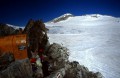
Upload picture
Description
Stále otevřený neobhospodařovaný bivak.
Edit description
Water source
...
Edit water parameters
Best time to visit
...
Edit visit time
Access
Z Rif. Prudenzini 4 hod.
Edit access
Notes
There is no comment on this object yet, so if you know something, try to add it here...
Add a note
© www.boudy.org
| all informations without guarantee | PHP 8.3.30 | MySQL 11.4.10-MariaDB-ubu2204-log | last change: 06/01/2024 - 22:05:09 V.A.