
CAI Tarvisio
 Main info


...")


9
/
12
GPS WGS84:
46° 26’ 21.12” N
13° 40’ 43.85” E
Link: ww.cai.it
Added by: Kája (04/02/2005 - 18:46:04)
Link: ww.cai.it
Added by: Kája (04/02/2005 - 18:46:04)
Map
Objects in the surroundings


There have been 14 other objects found in the area, if you know of any others, try adding them here...
Gallery
653

651
652
There are 3 of pictures in the gallery, if you have some more, you can upload them here...
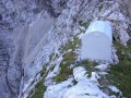
Description
- wooden bunk beds
- přikrývky
...
Water source
- the surrounding area is without water in times of drought
Nejbližší voda je hluboko v údolí směrem do Slovinska na sněhových polích.
Best time to visit
- acute avalanche danger
...
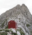
Access
V létě po ferátě (červená) nebo po hřebeni (2 UIAA) od Mangrtu na sedélko Sagherza. V zimě z Korytnice na lyžích údolím stále vzhůru.
Notes
20/07/2009 - 21:02:27
Bivak na skalním, částečně zatravněném břitu. Super spaní, dne 17. 07. 2009 ani noha. Pozor, z Logu pod Mangartom velmi těžké, na závěr lezení do 2. Z Italské strany od refugia Zachchi - via dela Vita - velmi těžká ferrata, navíc poškozená, nebo zajištěný hřeben přes Ponza Grande - též velmi těžké, k tomu velmi dlouhé. Avšak - vše velmi krásné.
legerski
There are 1 notes for this object...
© www.boudy.org | all informations without guarantee | PHP 8.3.30 | MySQL 11.4.10-MariaDB-ubu2204-log | last change: 06/01/2024 - 22:05:09 V.A.