
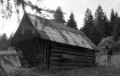
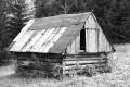
Seník pod Stanišovským sedlem
 Main info


4
/
8
GPS WGS84:
49° 0’ 14.59” N
19° 42’ 25.94” E
Added by: VA (21/02/2006 - 23:51:09)
Added by: VA (21/02/2006 - 23:51:09)
Map
Objects in the surroundings


There have been 12 other objects found in the area, if you know of any others, try adding them here...
Notes
13/01/2022 - 22:02:33
Seník už jsme nenašli, okolo je vícero zamčených chatek, které vypadají jako přestavěné seníky...
zuzkamat
There are 1 notes for this object...
Gallery
511
512
There are 2 of pictures in the gallery, if you have some more, you can upload them here...
© www.boudy.org | all informations without guarantee | PHP 8.3.30 | MySQL 11.4.10-MariaDB-ubu2204-log | last change: 06/01/2024 - 22:05:09 V.A.