
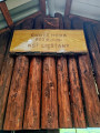
Prístrešok Chotá hora
 Main info


...")


4
/
6
GPS WGS84:
48° 50’ 15.25” N
18° 29’ 51.9” E
Added by: VA (10/09/2025 - 15:27:50)
Added by: VA (10/09/2025 - 15:27:50)
Map
Objects in the surroundings


There have been 10 other objects found in the area, if you know of any others, try adding them here...
Gallery
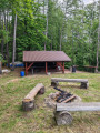
3696
10/05/2025 - 15:26:48
Shelter in spring 2025.
VA
3697

10/05/2025 - 15:28:09
Shelter in spring 2025.
VA
3698
10/05/2025 - 15:28:47
Shelter in spring 2025.
VA
3699
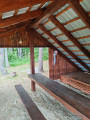
10/05/2025 - 15:29:33
Interior.
VA
3700
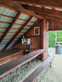
10/05/2025 - 15:30:26
Interior.
VA
There are 5 of pictures in the gallery, if you have some more, you can upload them here...
Notes
There is no comment on this object yet, so if you know something, try to add it here...
© www.boudy.org | all informations without guarantee | PHP 8.3.30 | MySQL 11.4.10-MariaDB-ubu2204-log | last change: 06/01/2024 - 22:05:09 V.A.