
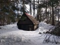
Útulňa pod vrcholom Vtáčnik
 Main info


...")


6
/
8
GPS WGS84:
49° 3’ 53.36” N
19° 13’ 26.42” E
Added by: VA (20/11/2023 - 16:16:27)
Added by: VA (20/11/2023 - 16:16:27)
Map
Objects in the surroundings


There have been 29 other objects found in the area, if you know of any others, try adding them here...
Gallery
3544
3543
3542
There are 3 of pictures in the gallery, if you have some more, you can upload them here...
Description
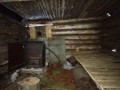
- wooden bunk beds
- table
- benches / chairs
- clay floor
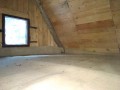
- wooden floor
- heater with hotplate
- saw
- ax
Log building with attic floor, honest waterproof roof. Inside stove with stove, wooden bunk, in the attic another flat area for a bivouac.
Water source
Some of the springs under the shelter - see map.
Best time to visit
Probably anytime...
Access
The building is located below the Vtáčnik peak on a side ridge heading approximately east from the peak, with an unmarked footpath leading to it from the Kalisko saddle on the red trail.
- VKÚ TM 121 - Veľká Fatra 1 : 50 000
Notes
There is no comment on this object yet, so if you know something, try to add it here...
© www.boudy.org | all informations without guarantee | PHP 8.3.31 | MySQL 11.4.10-MariaDB-ubu2204-log | last change: 06/01/2024 - 22:05:09 V.A.