Česky
|
English
www.boudy.org
Open database of mountain huts, tourist shelters, sheds and bivouacs
Index
Search for object
View map
Add an object
Export GPS
Axerio
Italy
,
Monte Rosa e Cervino
,
Monte Rosa
| 2 672 m a.s.l.
Main info
5
/
10
GPS WGS84:
45° 54’ 17” N 7° 58’ 32” E
Added by:
Kája (13/04/2004 - 21:33:38)
Gallery
Notes
Edit object
Map
Cannot view map !!!
JavaScript is required to view the map...
Objects in the surroundings
Lanti E.
1.1 km, ↘ 547 m
Resegotti L.
6.2 km, ↗ 952 m
Gugliermina (ex Valsesia)
7.2 km, ↗ 540 m
Marinelli D.
8 km, ↗ 364 m
Alpe Sella Alta
8.8 km, ↘ 625 m
Belloni V.
8.8 km, ↘ 163 m
Giordano F. (Balmenhornbiwak)
9.2 km, ↗ 1495 m
Hinderbalmo - Kovacs B.
9.2 km, ↘ 762 m
Cittá di Gallarate
9.2 km, ↗ 1298 m
Ravelli L.
10.7 km, ↘ 169 m
Antigine
11 km, ↗ 163 m
Citté di Luino
11.1 km, ↗ 890 m
Alpe Cavaglione
11.2 km, ↘ 1041 m
Longa B.
11.4 km, ↘ 636 m
Alpe Campo
13 km, ↘ 782 m
Gastaldi C.
13 km, ↘ 112 m
Lamé bivacco
14.2 km, ↘ 250 m
There have been 17 other objects found in the area, if you know of any others, try adding them here...
Add new object
Gallery
381
There are 1 of pictures in the gallery, if you have some more, you can upload them here...
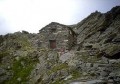
Upload picture
Description
Stále otevřené přístřeší pro 8 osob.
Edit description
Water source
...
Edit water parameters
Best time to visit
Asi kdykoliv...
Edit visit time
Access
...
Edit access
Notes
There is no comment on this object yet, so if you know something, try to add it here...
Add a note
© www.boudy.org
| all informations without guarantee | PHP 8.3.30 | MySQL 11.4.10-MariaDB-ubu2204-log | last change: 06/01/2024 - 22:05:09 V.A.