
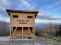
Útulňa SNP Úhorná
 Main info


...")


6
/
10
GPS WGS84:
48° 41’ 50.31” N
20° 39’ 11.56” E
Added by: VA (16/09/2023 - 23:20:16)
Added by: VA (16/09/2023 - 23:20:16)
Map
Objects in the surroundings


There have been 4 other objects found in the area, if you know of any others, try adding them here...
Gallery
3435

3434

3433
There are 3 of pictures in the gallery, if you have some more, you can upload them here...
Description
- benches / chairs
- wooden floor
- fireplace
- ax
- shovel
- first aid kit
Nová turistická útulna nedaleko Úhornianského sedla přímo na červené značce - trase Cesty hrdinou SNP. 2 podlažní objekt, dole otevřený prostor kolem ohniště s lavicemi, v patře obytná místnost vytápěná komínem z přízemí. Na útulni instalován fotovoltaický panel, elektrické osvětlení, možnost dobytí mobilního telefonu.
Water source
- the surrounding area is without water in times of drought
Nedaleký Prameň Smolníka.
Best time to visit
- tourist season - limited capacity
Raději asi mimo sezónu.
Access
Objekt se nachází přímo na červené značce - trse Cesty hrdinou SNP a zároveň Rudné magistrále, cca 500 m před Úhornianským sedlem (ve směru od Košic).
- VKÚ TM 125 Volovské vrchy – Krompachy 1 : 50 000
Notes
There is no comment on this object yet, so if you know something, try to add it here...
© www.boudy.org | all informations without guarantee | PHP 8.3.31 | MySQL 11.4.10-MariaDB-ubu2204-log | last change: 06/01/2024 - 22:05:09 V.A.