
Opuštěný lom
 Main info


...")


20
/
30
GPS WGS84:
49° 24’ 34.41” N
15° 55’ 23.85” E
Added by: Alex (26/09/2021 - 14:12:17)
Added by: Alex (26/09/2021 - 14:12:17)
Map
Objects in the surroundings


There have been 9 other objects found in the area, if you know of any others, try adding them here...
Gallery
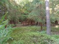
3265
02/08/2021 - 14:12:17
Plácek k táboření uvnitř lomu, jeden ze tří
Alex
3266
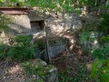
02/08/2021 - 14:12:18
Pozůstatky drtičky kamene jižně pod lomem
Alex
3267

02/08/2021 - 14:12:18
Plácek k táboření další
Alex
There are 3 of pictures in the gallery, if you have some more, you can upload them here...
Notes
There is no comment on this object yet, so if you know something, try to add it here...
© www.boudy.org | all informations without guarantee | PHP 8.3.31 | MySQL 11.4.10-MariaDB-ubu2204-log | last change: 06/01/2024 - 22:05:09 V.A.