
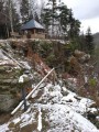
Altán nad otočkou
 Main info


...")


6
/
8
GPS WGS84:
50° 47’ 21.8” N
14° 29’ 21.41” E
Added by: Roman (28/01/2021 - 16:45:18)
Added by: Roman (28/01/2021 - 16:45:18)
Map
Objects in the surroundings


There have been 27 other objects found in the area, if you know of any others, try adding them here...
Gallery
3238
3239

There are 2 of pictures in the gallery, if you have some more, you can upload them here...
Description
- table
- clay floor
- open fireplace
...
Water source
Voda (pitná) je dostupná ve studánce asi 5 minut cesty od altánu.
50.7904208N, 14.4905022E
Best time to visit
...
Access
Z křižovatky v Horním Prysku (Polevsko, Prácheň, Česká Kamenice) jděte směrem na Prácheň a po asi 50 m odbočte do prava a vystoupejte po schodech nad domy.
Notes
There is no comment on this object yet, so if you know something, try to add it here...
© www.boudy.org | all informations without guarantee | PHP 8.3.30 | MySQL 11.4.10-MariaDB-ubu2204-log | last change: 06/01/2024 - 22:05:09 V.A.