
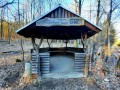
Přístřešek Štěchovice
 Main info


...")


4
/
??
GPS WGS84:
49° 50’ 9.47” N
14° 24’ 56.49” E
Added by: Petr Dvořák (03/07/2020 - 20:36:41)
Added by: Petr Dvořák (03/07/2020 - 20:36:41)
Map
Objects in the surroundings
There have been 1 other objects found in the area, if you know of any others, try adding them here...
Gallery
3508
There are 1 of pictures in the gallery, if you have some more, you can upload them here...
Description
- benches / chairs
- clay floor
Volný přístřešek pro bivak ve výborném technickém stavu. Částečné závětří.
Water source
- the surrounding area is without water in times of drought
- there is only utility water in the vicinity
Asi 100 metrů východním směrem je pramen vody. Pitná nejspíš není. Pro pitnou vodu musíte asi 1 kilometr po modré turistické značce, směr Štěchovice.
Best time to visit
- tourist season - limited capacity
- tourist season
- hunting season
Celoročně.
Access
Přístřešek se nachází na červené TZN na rozcestí, asi 1.5 km za obcí Štěchovice, směrem na obec Třebenice. Od přístřešku vede modrá turistická značka k rozcestníku Nad přehradou, kde začíná stezka Svatojánské proudy.
Notes
There is no comment on this object yet, so if you know something, try to add it here...
© www.boudy.org | all informations without guarantee | PHP 8.3.30 | MySQL 11.4.10-MariaDB-ubu2204-log | last change: 06/01/2024 - 22:05:09 V.A.