
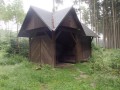
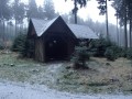
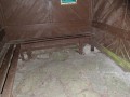
Přístřešek
 Main info


4
/
6
GPS WGS84:
49° 13’ 42.01” N
15° 21’ 23.66” E
Added by: Nazgul (17/01/2018 - 12:17:47)
Added by: Nazgul (17/01/2018 - 12:17:47)
Map
Objects in the surroundings


There have been 7 other objects found in the area, if you know of any others, try adding them here...
Gallery
2974
2975
2973
There are 3 of pictures in the gallery, if you have some more, you can upload them here...
Description
- benches / chairs
- stone floor
...
Water source
...
Best time to visit
...
Access
Objekt leží přímo u zelené značky.
Notes
There is no comment on this object yet, so if you know something, try to add it here...
© www.boudy.org | all informations without guarantee | PHP 8.3.30 | MySQL 11.4.10-MariaDB-ubu2204-log | last change: 06/01/2024 - 22:05:09 V.A.