
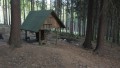
Seník pod Černým vrchem
 Main info


2
/
4
GPS WGS84:
50° 48’ 29.5” N
14° 48’ 32.96” E
Added by: Chidling (20/11/2017 - 12:14:51)
Added by: Chidling (20/11/2017 - 12:14:51)
Map
Objects in the surroundings


There have been 17 other objects found in the area, if you know of any others, try adding them here...
Gallery
2942
There are 1 of pictures in the gallery, if you have some more, you can upload them here...
Description
Hezký a vcelku nový seník na čtyřech kůlech, spaní v patře na zásobárně sena, případně na prkenné podlaze.
Water source
...
Best time to visit
...
Access
Je vidět ze zelené značky (cca 70m od ní), mezi rozcestími Pekařův Kříž a U Tří pánů.
- https://mapy.cz/s/2d4Kh
Notes
There is no comment on this object yet, so if you know something, try to add it here...
© www.boudy.org | all informations without guarantee | PHP 8.3.31 | MySQL 11.4.10-MariaDB-ubu2204-log | last change: 06/01/2024 - 22:05:09 V.A.