
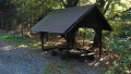
Přístřešek pod Luží
 Main info


4
/
4
GPS WGS84:
50° 50’ 46.8” N
14° 38’ 39.51” E
Added by: Chidling (19/11/2017 - 11:13:50)
Added by: Chidling (19/11/2017 - 11:13:50)
Map
Objects in the surroundings


There have been 25 other objects found in the area, if you know of any others, try adding them here...
Gallery
2936
There are 1 of pictures in the gallery, if you have some more, you can upload them here...
Description
Přístřešek u odbočky červené značky k vrcholu Luže. Poměrně velký, jeho užití je ale omezeno středovým kulatým "stolem" z kmene stromu. Vyspat se ale dá na místě lavic, které lze odsunout.
Water source
Studánka "Pod Luží" na 50.8480783N, 14.6446653E byla v září 2017 na suchu.
Best time to visit
...
Access
...
- https://mapy.cz/s/2d4B9
Notes
There is no comment on this object yet, so if you know something, try to add it here...
© www.boudy.org | all informations without guarantee | PHP 8.3.30 | MySQL 11.4.10-MariaDB-ubu2204-log | last change: 06/01/2024 - 22:05:09 V.A.