
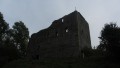
Zřícenina hradu Kamenice
 Main info


...")


8
/
16
GPS WGS84:
50° 47’ 28.66” N
14° 25’ 59.96” E
Added by: Chidling (18/11/2017 - 10:55:10)
Added by: Chidling (18/11/2017 - 10:55:10)
Map
Objects in the surroundings


There have been 24 other objects found in the area, if you know of any others, try adding them here...
Gallery
2914
2915
2916

There are 4 of pictures in the gallery, if you have some more, you can upload them here...
Description
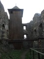
- wooden floor
Vyhlídková dřevěná věž poskytuje dostatek místa pro spaní na vrchní vyhldkové plošině a dále v mezipatrech mezi schody. Zřejmě bez hromosvodu, tedy při bouřce nedoporučuji!
Water source
...
Best time to visit
...
Access
...
- https://mapy.cz/s/2cTbS
Notes
There is no comment on this object yet, so if you know something, try to add it here...
© www.boudy.org | all informations without guarantee | PHP 8.3.31 | MySQL 11.4.10-MariaDB-ubu2204-log | last change: 06/01/2024 - 22:05:09 V.A.