
Trollkyrkjetjønne hytte
 Main info


...")


2
/
6
GPS WGS84:
62° 12’ 20.47” N
7° 56’ 15.65” E
Added by: (24/10/2016 - 07:31:45)
Added by: (24/10/2016 - 07:31:45)
Map
Objects in the surroundings
No other object has been found in the area, if you know of one, please try to add it here...
Gallery
No picture found in the gallery, if you have one, you can upload it here...
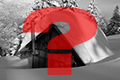
Description
- beds
- mattress
- přikrývky
- table
- benches / chairs
- wooden floor
- heater with hotplate
Rybářská chajda u které oficiálně končí trasa ale po mužících se dá dostat dál (kompas a mapa samozřejmost). Útulná dřevěná bouda. Dřevo na zatopení je asi pod chatou ale nejsem si uplně jistý.
Water source
Jezero.
Best time to visit
Asi kdykoliv.
Access
...
Notes
There is no comment on this object yet, so if you know something, try to add it here...
© www.boudy.org | all informations without guarantee | PHP 8.3.30 | MySQL 11.4.10-MariaDB-ubu2204-log | last change: 06/01/2024 - 22:05:09 V.A.