
Altán Lelkovadlo
 Main info


...")


2
/
4
GPS WGS84:
49° 18’ 42.16” N
16° 35’ 0.23” E
Added by: Nazgul (04/10/2016 - 11:33:10)
Added by: Nazgul (04/10/2016 - 11:33:10)
Map
Objects in the surroundings


There have been 10 other objects found in the area, if you know of any others, try adding them here...
Gallery
2807
There are 1 of pictures in the gallery, if you have some more, you can upload them here...
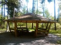
Description
- table
- benches / chairs
- stone floor
Altán Lelkovadlo poblíž Vranova.
Water source
...
Best time to visit
V noci.
Access
Odkudkoliv, přímo na rozcestí.
Notes
There is no comment on this object yet, so if you know something, try to add it here...
© www.boudy.org | all informations without guarantee | PHP 8.3.30 | MySQL 11.4.10-MariaDB-ubu2204-log | last change: 06/01/2024 - 22:05:09 V.A.