
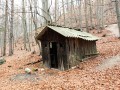
Búda pod hradom Uhrovec
 Main info


...")


2
/
4
GPS WGS84:
48° 44’ 57.14” N
18° 23’ 10.19” E
Added by: Martin Lihosith (31/05/2016 - 22:45:33)
Added by: Martin Lihosith (31/05/2016 - 22:45:33)
Map
Objects in the surroundings

There have been 2 other objects found in the area, if you know of any others, try adding them here...
Gallery
2767
2768
There are 2 of pictures in the gallery, if you have some more, you can upload them here...
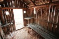
Description
- bed boards
- benches / chairs
- clay floor
...
Water source
Nie je.
Best time to visit
Jar, leto, jeseň.
Access
Búda leží na modrej značke medzi holým vrchom a hradom Uhrovec.
Notes
There is no comment on this object yet, so if you know something, try to add it here...
© www.boudy.org | all informations without guarantee | PHP 8.3.30 | MySQL 11.4.10-MariaDB-ubu2204-log | last change: 06/01/2024 - 22:05:09 V.A.