
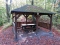
Přístřešek u Hričovského hradu
 Main info


...")


1
/
2
GPS WGS84:
49° 12’ 36.91” N
18° 37’ 12.07” E
Added by: Lukáš Zemánek (10/04/2016 - 19:55:24)
Added by: Lukáš Zemánek (10/04/2016 - 19:55:24)
Map
Objects in the surroundings


There have been 2 other objects found in the area, if you know of any others, try adding them here...
Gallery
3608
3607
There are 2 of pictures in the gallery, if you have some more, you can upload them here...
Description
- table
- benches / chairs
Dřevěný turistický přístřešek.
Water source
...
Best time to visit
- tourist season - limited capacity
Kdykoliv...
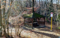
Access
Nachází se u rozcestníku pod Hričovským hradem na červeně značené stezce vedoucí z obce Hričovské Podhradie.
- Súlovské skaly
Notes
There is no comment on this object yet, so if you know something, try to add it here...
© www.boudy.org | all informations without guarantee | PHP 8.3.31 | MySQL 11.4.10-MariaDB-ubu2204-log | last change: 06/01/2024 - 22:05:09 V.A.