
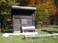
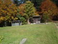
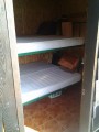
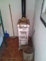
Mrkvište
 Main info


4
/
8
GPS WGS84:
44° 42’ 32.3” N
15° 2’ 55.37” E
Added by: Kaja (10/02/2016 - 23:05:36)
Added by: Kaja (10/02/2016 - 23:05:36)
Map
Objects in the surroundings
There have been 1 other objects found in the area, if you know of any others, try adding them here...
Gallery
2731
03/05/2016 - 23:05:36
Kaja
2732
03/05/2016 - 23:05:36
Kaja
2733
03/05/2016 - 23:05:36
Kaja
2734
03/05/2016 - 23:05:36
Kaja
2735
03/05/2016 - 23:05:36
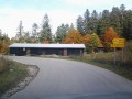
Pohled od silnice i s chatou.
Kaja
There are 5 of pictures in the gallery, if you have some more, you can upload them here...
Notes
There is no comment on this object yet, so if you know something, try to add it here...
© www.boudy.org | all informations without guarantee | PHP 8.3.30 | MySQL 11.4.10-MariaDB-ubu2204-log | last change: 06/01/2024 - 22:05:09 V.A.