
Bouda pod Knížecím stolcem
 Main info


3
/
8
GPS WGS84:
48° 50’ 58.36” N
14° 0’ 26.22” E
Added by: Nazgul (23/06/2014 - 23:28:24)
Added by: Nazgul (23/06/2014 - 23:28:24)
Map
Objects in the surroundings


There have been 15 other objects found in the area, if you know of any others, try adding them here...
Gallery
2607
11/04/2012 - 23:28:24
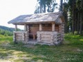
Altán, převzato z vojujezd-boletice.cz
Nazgul
2608
11/04/2014 - 23:28:24
Kaja
2609
11/04/2014 - 23:28:24
Kaja
2610
11/04/2014 - 23:28:24
Kaja
2611

11/04/2014 - 23:28:24
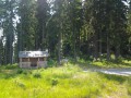
Bouda je přímo na tomto rozcestí
Kaja
There are 5 of pictures in the gallery, if you have some more, you can upload them here...
Notes
08/12/2014 - 16:13:13
Rozcestí a blízký vrcholek se jmenuje Skalky - viz fotka rozcestí.
Kaja
There are 1 notes for this object...
© www.boudy.org | all informations without guarantee | PHP 8.3.30 | MySQL 11.4.10-MariaDB-ubu2204-log | last change: 06/01/2024 - 22:05:09 V.A.