
Senník v Blatnickej doline
 Main info


5
/
10
GPS WGS84:
48° 55’ 30.72” N
18° 56’ 21.08” E
Added by: K (09/09/2013 - 21:56:34)
Added by: K (09/09/2013 - 21:56:34)
Map
Objects in the surroundings


There have been 35 other objects found in the area, if you know of any others, try adding them here...
Gallery
2505
2506
There are 2 of pictures in the gallery, if you have some more, you can upload them here...
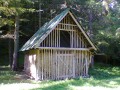
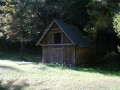
Description
Otevřený seník při cestě v Blatnické dolině. Leží necelý kilometr za posledními domy Blatnice v ohybu cesty po pravé straně pod stromy. Místo pro 5 lidí min.
Water source
Blatnický potok
Best time to visit
...
Access
Zelenou značkou Blatnickou dolinou, cca 800m, seník je vpravo od cesty.
Notes
There is no comment on this object yet, so if you know something, try to add it here...
© www.boudy.org | all informations without guarantee | PHP 8.3.30 | MySQL 11.4.10-MariaDB-ubu2204-log | last change: 06/01/2024 - 22:05:09 V.A.