
Opici hlava
 Main info


...")


3
/
6
GPS WGS84:
50° 35’ 23.9” N
14° 22’ 41.05” E
Added by: scinkk (13/08/2013 - 23:01:31)
Added by: scinkk (13/08/2013 - 23:01:31)
Map
Objects in the surroundings


There have been 9 other objects found in the area, if you know of any others, try adding them here...
Gallery
2466
There are 1 of pictures in the gallery, if you have some more, you can upload them here...
Description
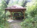
Pristresek bez stolu a lavic, podlaha vysypana oblazky.
Water source
- the surrounding area is without water in times of drought
Asi 200 m dolu po zlute, je znaceno v mapach, jen si nejsem jist, zda nebyl zdroj suchy. Vydatny zdroj je jeste po cervene smer Blizevedly cca 1 km.
Best time to visit
...
Access
Po žluté.
Notes
There is no comment on this object yet, so if you know something, try to add it here...
© www.boudy.org | all informations without guarantee | PHP 8.3.30 | MySQL 11.4.10-MariaDB-ubu2204-log | last change: 06/01/2024 - 22:05:09 V.A.