
Bouda u trati a rybníka Osovec
 Main info


10
/
15
GPS WGS84:
49° 21’ 42.13” N
16° 6’ 59.01” E
Added by: Kája (07/06/2006 - 13:59:21)
Added by: Kája (07/06/2006 - 13:59:21)
Map
Objects in the surroundings


There have been 9 other objects found in the area, if you know of any others, try adding them here...
Gallery
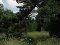
255
27/01/2007 - 13:59:21
Pohled od přístupu od rybníka.
Kája
256

27/01/2007 - 13:59:21
Kája
257
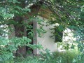
27/01/2007 - 13:59:21
V létě není bouda přes stromy moc vidět.
Kája
258
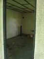
27/01/2007 - 13:59:21
Kája
259
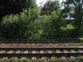
27/01/2007 - 13:59:21
pohled přímo přes trať
Kája
There are 5 of pictures in the gallery, if you have some more, you can upload them here...
Notes
21/06/2007 - 22:08:00
Přihodil jsem nějaké fotky - pořád domek stojí a je pořád ve stejném stavu.
Kaja
There are 1 notes for this object...
© www.boudy.org | all informations without guarantee | PHP 8.3.30 | MySQL 11.4.10-MariaDB-ubu2204-log | last change: 06/01/2024 - 22:05:09 V.A.