
Búda v Koprovej doline - Pod Temnými Smrečinami
 Main info


4
/
6
GPS WGS84:
49° 11’ 33.37” N
20° 0’ 51.24” E
Added by: K (11/01/2012 - 18:40:38)
Last edit: VA (25/01/2012 - 18:40:38)
Added by: K (11/01/2012 - 18:40:38)
Last edit: VA (25/01/2012 - 18:40:38)
Map
Objects in the surroundings


There have been 21 other objects found in the area, if you know of any others, try adding them here...
Gallery
2194
09/02/2011 - 18:40:38
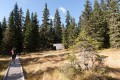
Bouda na podzim 2011.
VA
2195

09/02/2011 - 18:40:38
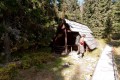
Interiér.
VA
2197

09/02/2011 - 18:40:38
Křižovatka k Hladkému sedlu.
VA
2198
09/02/2011 - 18:40:38
Bouda od stezky z Koprové doliny.
VA
2196
09/02/2012 - 18:40:38
Bouda na podzim 2011.
VA
There are 5 of pictures in the gallery, if you have some more, you can upload them here...
Notes
There is no comment on this object yet, so if you know something, try to add it here...
© www.boudy.org | all informations without guarantee | PHP 8.3.30 | MySQL 11.4.10-MariaDB-ubu2204-log | last change: 06/01/2024 - 22:05:09 V.A.