
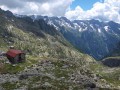
Rif. Allievi
 Main info


6
/
10
GPS WGS84:
46° 17’ 15.83” N
9° 39’ 49.72” E
Added by: Kaja (03/01/2012 - 18:17:21)
Added by: Kaja (03/01/2012 - 18:17:21)
Map
Objects in the surroundings


There have been 16 other objects found in the area, if you know of any others, try adding them here...
Gallery
2183
09/02/2012 - 18:17:21
2184
09/02/2012 - 18:17:21
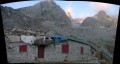
Velké stavení je Rif. Bonacossa, vstup do winterraumu je tam co je zelená šipka
2185
09/02/2016 - 18:17:21
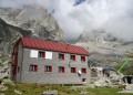
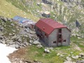
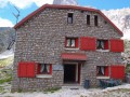
Rif. ALLIEVI-BONACOSSA
2186
09/02/2016 - 18:17:21
2187
09/02/2016 - 18:17:21
There are 5 of pictures in the gallery, if you have some more, you can upload them here...
Notes
28/06/2016 - 00:20:22
Rif. Allievi-Bonacossa 2385 m - nová chata S.E.M. vedle částečně pobořené staré (použitelný zbytek funguje jako winterraum), kapacita 40, respektují Alpenverein (12 €/noc), potíže s angličtinou. Výchozí bod pro Cima Zocca, Pta Alievi, Pizzo Torrione, Cima Castello a přechod po Via Roma pod Mte Disgrazia. kolem romantická skalní krajina a mraky lezení...
dolomiter
There are 1 notes for this object...
© www.boudy.org | all informations without guarantee | PHP 8.3.31 | MySQL 11.4.10-MariaDB-ubu2204-log | last change: 06/01/2024 - 22:05:09 V.A.